
The GPS Problem Nobody Notices Until GPS Disappears
There is a peculiar moment when a navigation app loses its mind.
The blue dot jumps onto the wrong road. The map rotates. The estimated arrival time becomes nonsense. For a few seconds, you do what humans did for thousands of years before smartphones: you look around.
A shop is on the left.
A bridge is ahead.
The road slopes downhill.
You work it out.
Then GPS returns, and the little blue dot becomes the authority again.
That tiny episode hides a much bigger technological assumption.
We have become so accustomed to machines knowing where they are that we rarely ask how they know.
And, more importantly:
What happens when the answer is wrong?
GPS is no longer simply a way of finding a restaurant or navigating home. The broader Global Navigation Satellite System, or GNSS, provides positioning, navigation and timing the three things collectively known as PNT. GPS itself is a U.S.-owned system providing those services.
Aircraft use it.
Ships use it.
Telecommunications networks use precise timing derived from satellite navigation.
Financial and industrial systems depend on accurate time.
Agriculture, surveying, logistics and autonomous machines use positioning.
Spacecraft use navigation references.
And increasingly, autonomous systems use location as part of their understanding of reality.
The uncomfortable part is that GNSS signals are extraordinarily weak by the time they reach Earth.
That is one reason they are so useful.
It is also one reason they can be disrupted.
Jamming tries to drown the real signal.
Spoofing is more devious: it supplies a convincing false one.
And a false location can be more dangerous than no location at all.
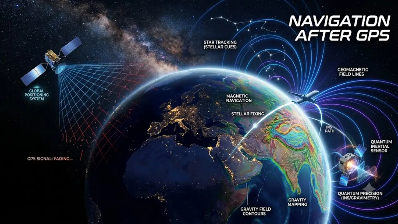
This is why the next generation of navigation is not really about building another GPS.
It is about building a world in which GPS can fail without taking navigation down with it.
The real GPS problem is not that GPS can disappear
Imagine an aircraft cruising thousands of metres above the ground.
Its GPS receiver suddenly reports that the aircraft is somewhere else.
There are two possibilities.
The receiver could say:
“I have no idea where I am.”
Or it could say:
“I know exactly where I am.”
The first is inconvenient.
The second can be dangerous.
That difference explains why engineers worry so much about spoofing.
NIST’s PNT framework treats positioning, navigation and timing data as vulnerable to disruption or manipulation from natural, accidental and deliberate sources.
This is not merely a military problem.
A modern navigation system is increasingly a sensor of reality.
If the sensor is deceived, everything downstream can make perfectly logical decisions based on a false premise.
That is a much more interesting problem than “GPS stops working.”
GPS is secretly a clock
Most people think satellites tell their phones where they are.
Technically, the receiver is doing something more interesting.
It is measuring extremely precise differences in the arrival time of signals from satellites whose positions and clocks are known.
In other words, GPS is partly a giant timing system.
The receiver uses those timing relationships to solve for its position and clock error.
This is why the loss of satellite navigation can affect things that do not appear to have anything to do with maps.
NIST describes PNT as important to critical infrastructure and specifically highlights the resilience requirements surrounding systems that depend on these services.
The hidden dependency therefore looks something like this:
GPS → precise time → synchronised systems → infrastructure
Remove the first component and the consequences may appear somewhere completely different.
A person may still be able to drive without GPS.
A telecom network has a rather different relationship with time.
That is the first major misconception worth killing:
A GPS outage is not necessarily a map outage.
It can be a timing outage.
The obvious backup is actually very old
Suppose you are flying and someone switches off satellite navigation.
There is one technology that does not suddenly stop knowing where you are.
Inertial navigation.
Gyroscopes measure rotation.
Accelerometers measure changes in motion.
A computer combines those measurements and continuously estimates position.
No satellites are required.
No radio signal has to reach the aircraft.
No external transmitter has to tell it what to do.
This sounds like the perfect answer.
It isn’t.
Inertial systems accumulate error.
A tiny measurement bias becomes a small position error.
A small position error becomes a larger one.
Over enough time, the estimated position drifts away from reality.
It is the technological equivalent of walking in a straight line while being wrong by a fraction of a degree.
At first, you barely notice.
Eventually, you are nowhere near the place you thought you were.
GPS became powerful partly because it could repeatedly correct that drift.
So the real challenge is not inventing inertial navigation.
It is making inertial navigation stay accurate for much longer without external correction.
And that is where the story gets very strange.
The quantum sensor that wants to replace your missing satellites
In 2024, British and American researchers flew a quantum sensor aboard an aircraft in a test designed to explore navigation without satellite signals.
The device used an unusual state of matter called a Bose-Einstein condensate: atoms cooled to extraordinarily low temperatures and manipulated with lasers.
The point was not to make atoms behave strangely for the sake of it.
The quantum behaviour provides an exceptionally sensitive way of measuring acceleration.
That matters because acceleration is exactly the information an inertial navigation system needs.
Recent testing has pushed this technology closer to practical navigation applications. Reporting in September 2026 describes multiple new trials involving quantum and alternative navigation technologies, including airborne quantum sensing and magnetic navigation.
But headlines claiming that quantum sensors are about to “replace GPS” need a reality check.
They are not.
Not yet.
A quantum sensor can be extremely sensitive, but sensitivity is only one part of a navigation system.
You also need:
compact hardware,
stability,
calibration,
resistance to vibration,
manageable power consumption,
affordable manufacturing,
reliable operation outside laboratory conditions,
and algorithms capable of turning measurements into useful navigation.
The important breakthrough is therefore not:
Quantum sensors have defeated GPS.
It is:
Quantum sensors are becoming credible candidates for keeping navigation alive when GPS cannot be trusted.
That is a much more defensible and much more interesting claim.
Then scientists tried something even stranger: navigating by gravity
Earth does not have the same gravitational field everywhere.
Mountains, rock formations, ocean structures and variations in the Earth’s crust produce tiny changes in local gravity.
Normally, humans never notice.
A quantum gravimeter can.
And if those variations are mapped, they can potentially become a kind of invisible geographical fingerprint.
A vehicle measures gravity.
The navigation computer compares the measurement with a gravity map.
The system asks:
“Where on Earth does the gravitational fingerprint I am measuring best match the map?”
That is map matching but the map is invisible.
In August 2026, researchers reported a striking advance.
A mobile quantum gravimeter was operated aboard a 29-metre surface vessel and used to perform gravity-map matching without GNSS. Over an 83-kilometre maritime trajectory, the quantum sensor helped constrain inertial-navigation drift to nautical-mile-level positioning. The same study reported that atom referencing reduced long-term drift by about 70 times compared with the classical sensor channel in a 56-hour stationary test.
This is still research.
It was not a demonstration that ships can now throw their satellite receivers overboard.
But it is an important conceptual step.
Navigation no longer has to ask:
“Can I receive a signal?”
It can ask:
“What physical fingerprint am I passing through?”
Earth itself may be a navigation system
This idea becomes even more fascinating when we look at animals.
Migrating birds can use Earth’s magnetic field as part of their navigation.
Sea turtles appear to do something even more remarkable.
Research has shown that juvenile loggerhead turtles can learn magnetic signatures associated with different geographical locations, suggesting that magnetic information can function not merely as a compass but as part of a navigational map.
That distinction matters.
A compass tells you:
Which direction?
A map tells you:
Where am I?
Nature appears to have evolved ways of extracting both kinds of information from Earth’s magnetic environment.
Humans are now attempting something conceptually similar with magnetometers.
Instead of asking a satellite where the vehicle is, a navigation system can measure Earth’s magnetic field and compare the pattern against a stored map.
The attraction is obvious.
The magnetic field is already there.
Nobody has to transmit it.
There is nothing obvious to jam in the conventional sense.
But again, there is no magic.
Magnetic fields vary.
Electrical infrastructure can interfere.
Local magnetic anomalies may be too weak or ambiguous.
The map has to be accurate.
The sensors have to be good.
So magnetic navigation is another piece of the puzzle, not a universal replacement.
The most important navigation technology may be one that does not navigate
There is another answer hiding in plain sight.
Instead of making the navigation sensor better, make the system better at recognising when one sensor is lying.
This is where sensor fusion becomes enormously important.
Imagine a future aircraft receiving:
GNSS: “You are here.”
Inertial system: “Your motion says otherwise.”
Magnetometer: “The magnetic environment does not match.”
Camera: “The terrain doesn’t look right.”
Quantum sensor: “Your acceleration history disagrees with the satellite-derived position.”
The old navigation philosophy might ask which sensor is correct.
The newer philosophy asks:
Which combination of evidence best explains reality?
That distinction is profound.
A navigation computer becomes less like a GPS receiver and more like a detective.
It does not blindly obey a signal.
It cross-examines it.
Recent research is already exploring machine-learning methods for detecting spoofed GNSS signals by comparing independent vehicle-state information, while ESA-backed work is investigating AI methods for identifying spoofed GNSS data.
The future may therefore involve AI not merely navigating, but deciding which navigation information deserves to be believed.
And then there is the old technology nobody expected to need again
The race away from GPS is producing an amusing technological reversal.
Some engineers are bringing back systems that GPS helped make obsolete.
One example is eLoran, an enhanced version of the old long-range navigation system.
Loran used powerful ground-based transmitters rather than extremely weak satellite signals.
Its signals can be much harder to overwhelm with a small jammer.
That does not make eLoran perfect.
But it illustrates a valuable engineering principle:
Sometimes resilience comes from going backwards.
A satellite-based signal and a terrestrial radio signal fail differently.
That is exactly what a backup should do.
If two systems have identical weaknesses, having both does not create much resilience.
If one depends on satellites and the other depends on powerful terrestrial transmitters, their failure modes are different.
That is useful.
What if the satellites themselves change?
Another solution is surprisingly simple:
Don’t abandon satellite navigation.
Add more layers of satellites.
ESA’s Celeste programme is pursuing a low-Earth-orbit navigation layer designed to complement Galileo and other GNSS systems.
The initial demonstrator involves 11 satellites intended to test new navigation signals and evaluate how LEO systems can work alongside existing GNSS infrastructure. ESA explicitly describes the architecture as a multi-layer approach intended to improve PNT resilience.
Why does orbit matter?
A navigation signal from a lower orbit can have different characteristics from traditional GNSS signals.
A larger number of rapidly moving satellites can also create different geometry and potentially improve resilience.
Again, however, this is not “GPS 2.0.”
It is more like adding another floor to the navigation building.
If one floor becomes unusable, the building still has others.
The spacecraft problem is even stranger
On Earth, you have roads, mountains, radio towers and Earth’s magnetic and gravitational fields.
In deep space, the situation becomes much more unforgiving.
There may be no GPS satellites nearby.
So what does a spacecraft use?
One answer is:
the stars.
More specifically, pulsars.
A pulsar is a rapidly rotating neutron star producing remarkably regular pulses of radiation.
NASA’s NICER/SEXTANT experiment demonstrated X-ray pulsar navigation in space. The technique treats pulsars as natural celestial reference points—essentially using the universe as a navigation beacon system. NASA describes the technology as a potential autonomous navigation capability for spacecraft travelling throughout the solar system and beyond.
Think about what this means.
GPS works because humans placed satellites around Earth.
Pulsar navigation works because the universe already contains clocks.
No ground station needs to transmit the signal.
No navigation constellation needs to be maintained around every planet.
The spacecraft can observe the sky and determine where it is.
That is not science fiction.
The demonstration has already happened.
The engineering challenge is making it practical, compact and accurate enough for future missions.
A spacecraft can also navigate by looking
Another emerging idea is even more intuitive.
Look at the planet.
Recognise what you see.
Compare the observed terrain with a stored map.
Estimate your position.
This is terrain-relative or optical navigation.
A spacecraft approaching the Moon, an asteroid or another planet can potentially use cameras to recognise surface features and determine where it is.
That changes the philosophy of navigation again.
Instead of receiving:
“You are at coordinate X.”
the spacecraft can calculate:
“The landscape beneath me resembles this location.”
NASA and ESA have both pursued autonomous navigation concepts based on onboard sensing and celestial or planetary references.
The long-term implication is enormous.
A spacecraft travelling far from Earth could increasingly carry the information needed to navigate with less dependence on Earth.
That is not merely a backup system.
It is a step toward genuinely autonomous exploration.
India has already recognised the strategic problem
India’s answer is not to abandon GPS.
It is to maintain independent capability.
NavIC, India’s regional satellite navigation system, provides positioning, navigation and timing services across India and beyond the country’s borders.
That matters because navigation is infrastructure.
A country that relies entirely on another country’s system inherits some of that system’s vulnerabilities and strategic dependencies.
NavIC therefore belongs to a broader trend toward independent PNT capability.
And modern receivers do not have to choose one constellation.
They can combine signals from multiple systems.
That is another important distinction:
independence does not necessarily mean isolation.
The most resilient system can use everybody’s signals while remaining capable of functioning when one source disappears.
So what actually happens when GPS disappears?
Probably not what movies suggest.
Cars do not instantly crash.
Planes do not suddenly fall from the sky.
Phones do not become expensive bricks.
The consequences depend on the duration, geographical extent and nature of the disruption.
A short local outage might produce annoying location errors.
A prolonged regional disruption could affect aviation operations, shipping, surveying and autonomous systems.
A large-scale timing disruption could reach telecommunications and other critical infrastructure.
The most vulnerable systems are not necessarily the ones that visibly use maps.
They are the systems that quietly assume that position and time will always be available.
That is why resilience matters more than replacement.
The future navigation stack may look like this
| Layer | What it measures | Main strength | Main weakness |
| GNSS | Satellite signals | Global, mature | Jamming/spoofing |
| Inertial | Motion and rotation | Works without external signals | Drift |
| Quantum inertial | Extremely precise motion | Low-drift potential | Complexity/cost |
| Magnetic | Earth’s field | Passive environmental reference | Local interference |
| Gravity | Earth’s gravity anomalies | Passive, difficult to spoof remotely | Requires detailed maps/sensitive sensors |
| Optical | Terrain/landmarks | Independent visual reference | Weather, lighting, map quality |
| LEO-PNT | Low-orbit satellite signals | Additional satellite layer | Still satellite-dependent |
| eLoran | Terrestrial radio | Stronger ground-based signal | Infrastructure required |
| Pulsars | Natural celestial pulses | Deep-space autonomy | Weak signals/long observation times |
Notice something.
There is no single winner.
That is precisely the point.
The most resilient navigator may be the one that knows when not to trust GPS
This may be the most important idea in the entire story.
For decades, navigation engineering was largely about increasing accuracy.
Now it increasingly has another job:
detecting deception.
An accurate sensor that is confidently wrong can be more dangerous than an imperfect sensor that knows it is uncertain.
This changes how navigation software must behave.
A resilient system should be able to say:
“The satellite signal says one thing. The inertial system says another. The magnetic field says something else. I therefore have reason to distrust the satellite solution.”
That is a very different philosophy from simply asking:
“What does GPS say?”
It is closer to scientific reasoning.
Measure.
Compare.
Cross-check.
Reject contradictions.
Update the estimate.
Navigation, in other words, is becoming a problem of epistemology how a machine knows what it knows.
The real future is not GPS-free. It is GPS-independent enough.
This distinction matters.
There will probably be no dramatic morning when humanity collectively switches off GPS and announces its replacement.
Instead, the transition will happen quietly.
Aircraft will receive more independent sensor inputs.
Autonomous vehicles will cross-check satellite positioning against cameras, inertial sensors and maps.
Ships will combine GNSS with inertial, radar, magnetic or gravity information.
Critical infrastructure will develop independent timing sources.
Spacecraft will increasingly navigate from stars, planets and onboard sensors.
Low-orbit navigation layers will complement existing constellations.
Quantum sensors will gradually move from impressive laboratory instruments toward practical field systems.
And AI will increasingly become the referee deciding whether different sensors agree.
That is much more plausible than the idea of a single revolutionary “GPS killer.”
The paradox at the centre of navigation
We built GPS because humans wanted to know where they were.
Then we connected more and more of civilisation to it.
Now we are building alternatives because we have discovered something uncomfortable:
Knowing your location is not enough. You must also know that the information telling you your location can be trusted.
That is why the most interesting developments are not competing to become the next GPS.
They are trying to make GPS optional when necessary.
Quantum sensors measure motion.
Gravity provides a geographical fingerprint.
Earth’s magnetic field offers another.
Cameras recognise landscapes.
Inertial systems remember movement.
Terrestrial signals provide another path.
LEO satellites add another layer.
Pulsars provide natural celestial references.
And sensor fusion tries to determine which pieces of evidence deserve belief.
The result could be a navigation system that is less elegant than GPS but much harder to break.
And perhaps that is the mature version of modern technology.
Not a system that never fails.
A system that fails gracefully.
Because the most dangerous navigation system is not the one that says:
“I don’t know where I am.”
It is the one that says:
“I know exactly where I am.”
—when it doesn’t.
Key Unfoldings
GPS is unlikely to simply disappear, but dependence on a single PNT source is increasingly viewed as a resilience problem.
The emerging answer is not one replacement technology. It is a layered architecture combining GNSS with inertial, quantum, magnetic, gravity, optical, terrestrial and alternative satellite systems.
Quantum sensing is particularly interesting because recent 2026 demonstrations are beginning to address real-world GNSS-denied navigation rather than merely laboratory measurements. The August 2026 quantum-gravity experiment is an especially significant example, although it remains experimental rather than a commercial GPS substitute.
For spacecraft, the idea becomes even more radical: natural celestial objects such as pulsars can act as navigation references without depending on Earth’s navigation constellation.
The deeper shift is therefore not “What will replace GPS?”
It is:
“How many independent ways can a machine have to discover where it really is?”
That is the navigation race worth watching.
2026 Research Worth Watching
A particularly important new development is the August 2026 preprint reporting a GNSS-independent quantum gravity-map navigation demonstration aboard a surface vessel. The researchers report an 83 km trajectory, nautical-mile-level positioning constraints and substantially reduced long-term inertial drift. It remains experimental and has not yet established a consumer-ready navigation replacement, but it is exactly the kind of field demonstration that could push quantum navigation from an intriguing concept toward practical GNSS-denied applications.
Recent reporting also documents new 2026 trials involving quantum inertial sensing, magnetic navigation and other layered approaches, reinforcing the emerging consensus that there is no single silver bullet for replacing satellite navigation.
Frequently Asked Questions
Can quantum sensors completely replace GPS?
Not currently. Quantum sensors are being tested as highly precise inertial or gravity-sensing components for GNSS-denied navigation. Their most credible near-term role is as one layer of a resilient navigation architecture.
Can Earth’s magnetic field really be used for navigation?
Yes. Earth’s magnetic field contains spatial variations that can be measured and compared against magnetic maps. Animals also use magnetic information, although the biological mechanisms remain an active scientific research area.
Can a spacecraft navigate without GPS?
Yes. Spacecraft can use inertial navigation, optical navigation, celestial references and other methods. NASA’s SEXTANT experiment demonstrated autonomous X-ray pulsar navigation in space.
What is pulsar navigation?
It is a navigation technique in which a spacecraft measures the timing of X-ray pulses from pulsars and uses them as celestial reference signals.
What happens if GPS is jammed?
The effect depends on the system. Navigation may degrade, become unavailable or produce unreliable results. Systems with inertial, terrestrial, optical or other independent references can continue operating with reduced dependence on GNSS.
Is spoofing worse than jamming?
They create different risks. Jamming attempts to prevent a receiver from using a signal. Spoofing attempts to make the receiver use false information. For autonomous systems, detecting false but plausible information can be particularly important.
Is NavIC India’s replacement for GPS?
NavIC is India’s own regional satellite navigation system. It provides an independent PNT capability but is better understood as part of a broader multi-GNSS environment rather than simply a replacement for GPS.
Will phones soon navigate using quantum sensors?
That is unlikely in the immediate future. Consumer devices face severe cost, size, power and manufacturing constraints. Quantum navigation is currently more relevant to high-value applications where GPS-denied operation justifies more sophisticated hardware.
What is the most realistic future of navigation?
A hybrid system. GNSS will probably remain extremely useful, but increasingly it will be checked and supplemented by inertial, terrestrial, optical, magnetic, gravity, quantum and alternative satellite technologies.
Sources and Further Reading
- GPS.gov — U.S. Government GPS information
- NIST — Positioning, Navigation and Timing
- ESA — Celeste LEO-PNT programme
- NASA — NICER/SEXTANT Pulsar Navigation
- NASA — X-ray Navigation Demonstration
- ISRO — NavIC
- ESA — GNSS jamming and spoofing research
- NASA Technical Reports Server — XNAV research







Leave a Reply